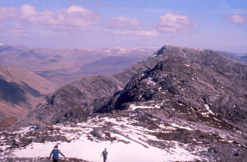
Half-way point, the ridge between Benbreen and Bencollaghduff, 1971 or 1972
Item
Format
JPEG
Title
Half-way point, the ridge between Benbreen and Bencollaghduff, 1971 or 1972
Identifier
VH0028
Description
One of 7 photographs taken during a day the UCG Mountaineering Club spent in the southern Twelve Bens in 1971 or 1972. For the other 6 photographs see 'A day on the Horseshoe ridge'.
In 2022 Michael Kane gave a vivid account of this day on the Horseshoe and the general activities of the Mountaineering Club. See 'Michael Kane's account of the Mountaineering Club c. 1971-72'.
The Mountaineering Club was established in 1970. Its membership in 2023 was over 1000.(Mountaineering Club, 'About us'). The Library archives contain a number of documents relating to the club. These were placed in the care of the University by Aengus Finnegan, Secretary 2010-2011 (Mountaineering Club, 'Archive').
The Glencoaghan (Gleann Chóchan) Horseshoe ridge is approximately 16 km long. Its peaks include 7 of the major bens: Binn Leitrí (Benlettery, 577m), Binn Ghleann Uisce (Ben Glenisky, 516m), Binn Gabhar (Bengower, 664m), Binn Bhraoin (Benbreen, 691m), An Bhinn Dubh (Bencollaghduff, 696m), Binn Chorr (Bencorr, 711m) and Binn Doire Chláir (Derryclare, 677m). It also comprises some subsidiary bens, among them Binn an Choire Bhig (Benncorrbeg, 577m) and Binn an tSaighdiúra (653m).
People
Unidentified members of the Mountaineering Club (1971-1972)
References
Personal communication:
Michael Kane (interview and written account)
Publications:
Galway Tourism, 'The Twelve Bens' [with map and hiking trails], https://www.galwaytourism.ie/connemara/the-twelve-bens/. Accessed 24 June, 2023.
Mountaineering Club, 'About us', https://nuigmc.com/about-us/. Accessed 20 June, 2023.
Mountaineering Club, 'Archive', https://nuigmc.com/wiki/index.php?title=Archive. Accessed 20 June, 2023.
Contributor
Bibliographic Citation
M. Kane, J. Conroy, 'Half-way point, the ridge between Benbreen and Bencollaghduff, 1971 or 1972', Visual History Retired Staff Collection, University of Galway Digital Collections, Asset Id 13725, Archival Record Id VHRS
Spatial Coverage
Temporal Coverage
Period
1970s
Category
colour
group
off-campus
outdoors
Language
English
Irish
Publisher
University of Galway Library
Rights
This image may be used for non-commercial purposes under CC BY-NC-SA see https://creativecommons.org/licenses/by-nc-sa/4.0/
Item sets
Linked resources
Filter by property
| Title | Alternate label | Class |
|---|---|---|
 Michael Kane's account of the Mountaineering Club c. 1971-1972 Michael Kane's account of the Mountaineering Club c. 1971-1972 |
Text |

